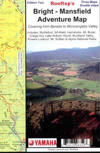

ROOFTOP MAPS - Bright/Mansfield
Description
Rooftop - Bright/Mansfield
Free Shipping Aust Wide!
The perfect map for exploring Bright's alpine area.
Map coverage is from Myrtleford, Bright, Moyhu and Benalla in the north to Mansfield, Mount Buller and Wonnangatta Station in the south. It includes Whitfield, Harrietville, Buckland, Buffalo River, Mount Buffalo, Powers Lookout and part of the Alpine National Park. Scale is 1:100,000.
The reverse of the map has a 1:50,000 scale enlargement titled 'Mount Buffalo Forest Activities Map' plus a 'Wonnangatta Aproaches Forest Activities Map', both with contours.
All parks, reserves and state forests are shown and all roads and tracks have been plotted using GPS mapping technology
Specifications
| SKU | 1041 |
| Brand | Rooftop |
| Shipping Weight | 0.1000kg |
| Shipping Width | 0.210m |
| Shipping Height | 0.150m |
| Shipping Length | 0.010m |
Reviews
Be The First To Review This Product!
Help other motospares users shop smarter by writing reviews for products you have purchased.
More From This Category
$12.95
or 4 payments of $3.24 with
 Info
Info
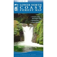
STATE FORESTS OF NSW - Lower North Coast Forest Map
$12.95
or 4 payments of $3.24 with
Info


