
ROOFTOP MAPS - Walhalla/Woods Point
Description
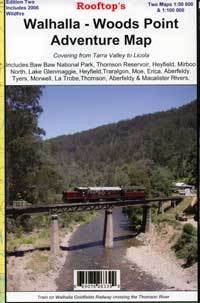
Rooftop - Walhalla/Woods Point
Free Shipping Aust Wide!
Edition Two 2006
The 2nd edition of this highly popular map has been extended through the Latrobe Valley to the South Gippsland Hills. Coverage now includes Baw Baw National Park, Thomson Reservoir, Heyfield, Mirboo North, Lake Glenmaggie, Traralgon, Moe, Erica, Aberfeldy, Tyers, Morwell, Blackwarry, Tarra-Bulga National Park and Won Wron.
Roads and tracks have been carefully plotted using a GPS and all important recreational and land features have been included plus the 2006 wildfire boundary in the Tyers and Moondarra State Parks.
The main map is at 1:100,000 scale. On the reverse side is the Walhalla - Woods Point Forest Activities Map at 1:50,000 scale with contours.
Specifications
| SKU | 1064 |
| Brand | Rooftop |
| Shipping Weight | 0.1000kg |
| Shipping Width | 0.210m |
| Shipping Height | 0.150m |
| Shipping Length | 0.010m |
Reviews
Be The First To Review This Product!
Help other motospares users shop smarter by writing reviews for products you have purchased.
More From This Category
$12.95
or 4 payments of $3.24 with
 Info
Info
STATE FORESTS OF NSW - Lower North Coast Forest Map
$12.95
or 4 payments of $3.24 with
Info


